
10 of B.C.'s best bike paths for a stress-free ride with stellar views


Positive pedalling is possible if you avoid some of the highly competitive biking spots in Metro Vancouver and head for some more relaxing B.C. routes that are perfect for all levels.
We’ve rounded up some of our favourites for any cyclists who love scenic rides with minimal stress. Remember, many trails are shared pathways, so be sure to make room for runners, walkers, or others enjoying what these locations have to offer.
No aggressive bike bells or throwing elbows here!
Seymour Valley Trailway

The Seymour Valley Trailway is perfect for cyclists of all levels, plus rollerbladers and pedestrians, too. (EB Adventure Photography/Shutterstock)
Check out the North Shore’s Lower Seymour Conservation Reserve’s (LSCR) stunning forest views from the comfort of your bike seat. The Seymour Valley Trailway is 10 km of paved road, so it’s perfect for biking beginners but also has plenty of options for more advanced trails throughout the massive reserve. Be sure to check out the Seymour Reservoir and Seymour River Hatchery on your trip. Expert advice: It’s great on a hot day, thanks to the ample tree cover, but remember to hydrate along the way.
Parking: There are several free parking lots in the area, and no reservations are required.
Extra tips: Road access in some spots may be limited during the winter months. There are also no garbage cans along the path, so pack it out and pack it in.
Address: 2369 Lillooet Rd., North Vancouver
Central Valley Greenway

The Central Valley Greenway takes you through Vancouver’s Science World and False Creek area plus New Westminster and Burnaby. (Shutterstock/Shawn.ccf)
This path is a perfect way to explore several cities all in one afternoon, as the 24 km route connects Vancouver to Burnaby and then downtown New Westminster. While it’s a longer route, it’s not overly hilly and has a great mix of different scenery. If you want to do a loop, connect to the BC Parkway path for a 50 km journey.
![]()
Some highlights: Hume Park in New Westminster, Burnaby Lake, and Telus World of Science in Vancouver.
Parking: It’s tough to suggest exactly where to start because it’s truly up to the rider’s original location, but many of the parks along the route have free parking. Or you can put your bike on the train (outside of peak hours) as the parkway connects to Millennium Line or Expo Line SkyTrain stations.
Traboulay Poco Trail

Port Coquitlam’s Traboulay Poco Trail. (Joanna Szypulska/Shutterstock)
Nature lovers, this one is a must-do. This Port Coquitlam trail can be up to 25 km long if you’re up for it, or broken up into shorter sections for a more casual ride. The mostly unpaved dirt route takes the rider along the North and South Pitt Rivers, historic Colony Farm, Minnekhada Regional Park, plus rich floodplains with hundreds of birds, and downtown Coquitlam for the urban jungle experience. It’s so nature-focused that there can be black bears in the area so be sure to keep your wits about you.
Parking: Several free parking lots along the route, including Hyde Creek, Gates Park, Pitt River Road, and Argue Street.
Extra tips: There are a fair number of public washrooms on this route.
Address: (To Lions Park Parking lot) 2300 Lions Way, Port Coquitlam, B.C.
Vedder Rotary Loop Trail

The Vedder Rotary Loop Trail in Chilliwack travels alongside the stunning Vedder River. (Matthew Collingwood/Shutterstock)
We love a loop! This 20+ km route takes riders along the Vedder River in Chilliwack, a popular spot for fishing and nature lovers, and is just a few kilometres away from Cultus Lake. This route is well-marked and easy to navigate and has lots to see and places to stop along the way. If you want to do a shorter bike ride, that’s possible too. Experts suggest starting at Vedder Park and heading in a counter-clockwise direction along the gravel trail towards the Keith Wilson Bridge before eventually crossing the water over the Vedder River Bridge before you end your adventure.
Parking: The easiest place to park is probably Vedder Park, but there are a few more spots as well, including Peach Park, Lickman Road, and Hopedale Road.
Extra tips: Bird lovers, be sure to stop at the Great Blue Heron Nature Reserve Interpretive Centre along this route.
Address: 45450 Petawawa Rd., Chilliwack
Lochside Regional Trail

From Swartz Bay Ferry Terminal to Victoria, the Lochside Regional Trail is a treat for ocean lovers. (pr2is/Shutterstock)
Off the mainland, there are even more bike paths to check out, including the stunning oceanic Lochside Trail, which travels between the Swartz Bay Ferry Terminal and Victoria. It seems ambitious, but this 29 km route is perfect for a fit cyclist who wants to see as much of Vancouver Island as possible in just a few hours before resting in the province’s capital city.
The route travels past the farmland of the Saanich Peninsula, plus has plenty of stops by the beach. It intersects with the incredible Galloping Goose Regional Trail for the even more ambitious rider. If you take that branch, you can check out the former railway line from Victoria to Sooke over the 55 km section. Be sure to plan a great spot to stay overnight in the area, because you’re going to want to have a rest after that grind!
Parking: You can take your bike onto the ferry and pay the cheaper sailing rate, but unfortunately, parking at the terminal is not free. If you’re already on the island, there are spots at Lochside Park in Saanich, Cy Hampson Park in Central Saanich, and Tulista Park in Sidney.
Extra tips: Feeling too tired to go on? There’s a bus that stops along parts of the route. Learn more here. Take note, asphalt replacement work is currently taking place along the trail in Sidney.
Address: 11300 Patricia Bay Hwy., Sidney, B.C.
Kettle Valley Rail Trail
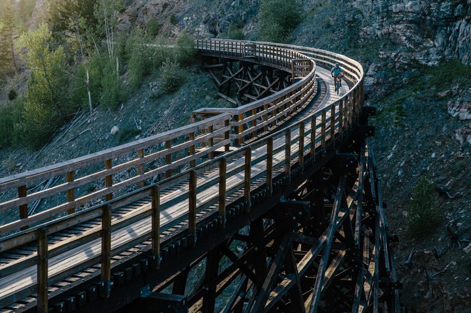
Kettle Valley Rail Trail, near Kelowna, is a trip to another time. (Destination BC/Grant Harder)
Named one of the most underrated spots in Canada a few years back, the Kettle Valley Rail Trail in the Okanagan is a celebrated spot for bike lovers of all levels, as it has a very minor incline in most spots.
Set along the decommissioned 1915 Kettle Valley Railway and boasting some 650 km of connected pathways, it can be whatever you want it to be: an easy afternoon of historic exploration, or a serious multi-day trip for a group getaway as you bike between Hope and south-central B.C.. Be sure to plan to visit the wineries when in the area, and book ahead when it comes to accommodation.
Extra tips: Make sure you visit the Myra Canyon stretch just south of the city of Kelowna, which has 18 thrilling wooden trestle bridges and two tunnels.
Address: Myra Canyon parking is at 1N0, Kettle Valley Rail Trail, Naramata.
Arbutus Greenway

Karynf/Shutterstock
Staying closer to home? It’s a surprise that some cyclists still haven’t used the Arbutus Greenway for a cycling-centred afternoon in Vancouver. The route was started in 2016, and while there are some small construction detours in places, the 9 km route is a paved paradise for the city biker who wants to explore from False Creek to the Fraser River, with lots of opportunities to stop and get some food along the way. If you want a longer workout, you can continue across the bridge to Richmond.
Parking: This is a tricky one, given that free street parking in the area is tough to come by. Granville Island (a few blocks away from the Kitsilano entrance) does have pay parking that can give riders peace of mind if they expect to be gone all day.
Extra tips: This route is very urban and serves as a commuting corridor, popular running spot, and training ground for some younger cyclists, so be sure to be respectful of other path users.
Address: Starts at Fir Street and West 5th, Vancouver, and ends at West 75th and Milton Street
Richmond’s West Dyke Trail

Steveston Village in Richmond is a perfect spot along your bike adventure to fuel up. (DorotaPhotography/Shutterstock)
This area has practically no hills, lots of fish and chip shops, and incredible scenery. There are lots of trails in Richmond, but one of the best is the West Dyck Trail because it offers spectacular mountain and ocean views, an estuary, migrating birds, and a stop in beautiful Steveston Village for a bite.
Parking: Garry Point Park has free parking, and there’s still some free street parking to be found in Steveston.
Extra tips: It’s about 6 km but you can go much further if you’re willing — the dyke system in Richmond connects to either Vancouver or Delta depending on your direction.
Address: 12011 Seventh Ave., Richmond, B.C.
Fort-to-Fort Trail

The Fort to Fort Trail is beautiful any time of year, but in the fall it’s even more photogenic. (karamysh/Shutterstock)
From Douglas Park in Langley City to Ridge Meadows Circle in Pitt Meadows and Maple Ridge, there are a lot of very cool bike paths in the Fraser Valley, but we wanted to highlight one of the most user-friendly routes.
The Fort-to-Fort Trail takes cyclists of all abilities along the Fraser River for a picturesque ride through nature as well as next to some pretty adorable local farms. The route is not only gorgeous but also has so much history to see, as it connects the Fort Langley National Historical Museum to the site of the original fort at Derby Reach.
Parking: There are quite a few free parking spots in Fort Langley (at the end of Mavis Avenue) or at Derby Reach Regional Park.
Extra tips: Depending on where you start the 10 km gravel path, you can end up having a quiet picnic by the river or exploring Fort Langley’s many restaurants and attractions, so plan your route (and lunch) accordingly.
Address: 10748 Allard Cres., Langley, B.C.
UBC

Pacific Spirit Regional Park on UBC Endowment lands is great for an afternoon bike ride or can be a stop on a longer route throughout the area near SW Marine Drive. (inEthos Design/Shutterstock)
Biking around UBC is beautiful and beachy — but is also uphill in some places. However, sweating along your way on this route is rewarding because of how many places you can explore, and on a summer day, you can even stop and cool off in the ocean.
The UBC Loop takes you along NW Marine Drive with its gorgeous beach views, then up through the university’s endowment lands. Stop at Wreck Beach or any of the other stunning beaches along the way, then continue along SW Marine Drive through Pacific Spirit Regional Park for some shade in the forest.
Extra tips: It’s about 30 km, but can be shorter or longer depending on your journey.
Address: Start at Jericho Beach Park (3941 Point Grey Rd., Vancouver), or anywhere along NW Marine Drive on the west side where there are free parking spots. However, they can be tough to find on a hot day, so head over early. If you park at UBC be ready to pay for parking or risk a ticket.
Where is your favourite place to bike? Let us know in the comments below.
This article was originally published in February 2024, and has since been updated.
- You might also like:
- No excuses: the best hikes for lazy people in Vancouver
- Best patios in Vancouver you need to check out this season
- The best places to take Instagram pictures in Vancouver
Want to stay on top of all things Vancouver? Follow us on X