Various levels of government have made great headway over the last three decades with restoring, rehabilitating, and protecting east-west creeks that run through East Vancouver, Burnaby, and New Westminster, but one Vancouver city councillor wants the region to go even further.
See also
- Lululemon seeking exemption to build 583,000-sq-ft office building in False Creek Flats
- City council declares climate change ‘an emergency’ for Vancouver
- Vancouver must spend $1 billion to protect itself from 1-metre rise in sea level
- $490-million expansion of East Vancouver community and recreational hub approved
Green Party councillor Michael Wiebe has proposed a motion requesting city staff create a plan to enable a continuous blueway that runs from False Creek to the Fraser River.
Much of this blueway already exists and is connected; the Brunette River ending in New Westminster connects with Burnaby Lake, which connects with Still Creek running through West Burnaby and East Vancouver. The Still Creek area near Brentwood is known to regularly flood each year, as it is a low-lying area of a large watershed.
Still Creek, running a length of 17 km, is one of only two remaining daylit streams within the city of Vancouver. The ‘rewilding’ of Still Creek over the years, in partnership with property owners, led to the return of spawning salmon in 2012 — the first time in about 80 years salmon returned to the waterway, and they have continued their annual return ever since.
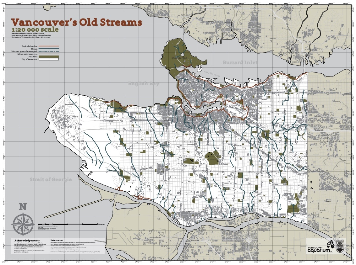
Extending the blueway further west to False Creek would require bringing Still Creek’s influence west to connect with Trout Lake via Renfrew Ravine, and daylighting China Creek, which used to be a surface waterway that flowed between Trout Lake and False Creek.
China Creek is currently buried in the False Creek Flats, but Wiebe notes that significant future redevelopments in the area create an opportunity to build around or daylight the stream.
This was also recently outlined as a possibility in lululemon’s preliminary plans to build a new major office complex in the southeast corner of the False Creek Flats, on a parcel where China Creek used to terminate into False Creek.

Map of Vancouver’s old streams in the area of Trout Lake, False Creek Flats, and Still Creek. (Vancouver Aquarium / UBC)
“Present day blueways can be managed from the perspective of ecological preservation and stormwater management while former blueways are treated by restoring or daylighting them,” reads his motion.
“Existing blueways and restored/daylighted blueways revive and protect ecosystems within our urban communities to help cities deal with the impacts of climate change. They improve water quality, absorb carbon and heavy rainfall, buffer floods, protect and expand urban forests, and increase biodiversity and wildlife habitats.”
Wiebe’s proposal requests city staff to report to city council in November 2019 for a blueways transformation plan along this route to the Fraser River in New Westminster. City staff would also explore opportunities for collaborative planning with the regional district, the City of Burnaby and the City of New Westminster, and outline the possibility of establishing a Blueways Enhancement Fund.
Earlier this year, city council also approved a Watershed Revival Plan, which directs city staff to create a comprehensive watershed management plan that includes strategies such as land acquisition, protecting existing waterway and habitat connections, daylighting streams, and intergovernmental coordination.
City council is scheduled to deliberate on Wiebe’s motion on May 14.
Click below for an expanded version of this detailed map of Vancouver’s old streams:

Map of Vancouver’s old streams. Click on the image for an expanded version. (Vancouver Aquarium / UBC)
See also
- Lululemon seeking exemption to build 583,000-sq-ft office building in False Creek Flats
- City council declares climate change ‘an emergency’ for Vancouver
- Vancouver must spend $1 billion to protect itself from 1-metre rise in sea level
- $490-million expansion of East Vancouver community and recreational hub approved

