City of Burnaby outlines 4 options for Highway 1 pedestrian and cyclist overpass

Where exactly should a pedestrian and cyclist overpass above the Trans-Canada Highway be built to improve accessibility and connections between Burnaby Lake Park to the north and Deer Lake Park to the south?
That is the question the City of Burnaby is aiming to answer through a public consultation on the project.
- You might also like:
- Landmark pedestrian bridge design over Highway 1 next to Burnaby Lake
- SFU Burnaby campus will get its own fire station
- New $145-million Holdom Avenue overpass proposed for Burnaby
- Burnaby approves 2.95% property tax increase, $504 million recreation centre plan
- New massive aquatic and recreational centre planned for Burnaby Lake (RENDERINGS)
- Bright and colourful: new permanent lighting installed on SkyTrain in Metrotown
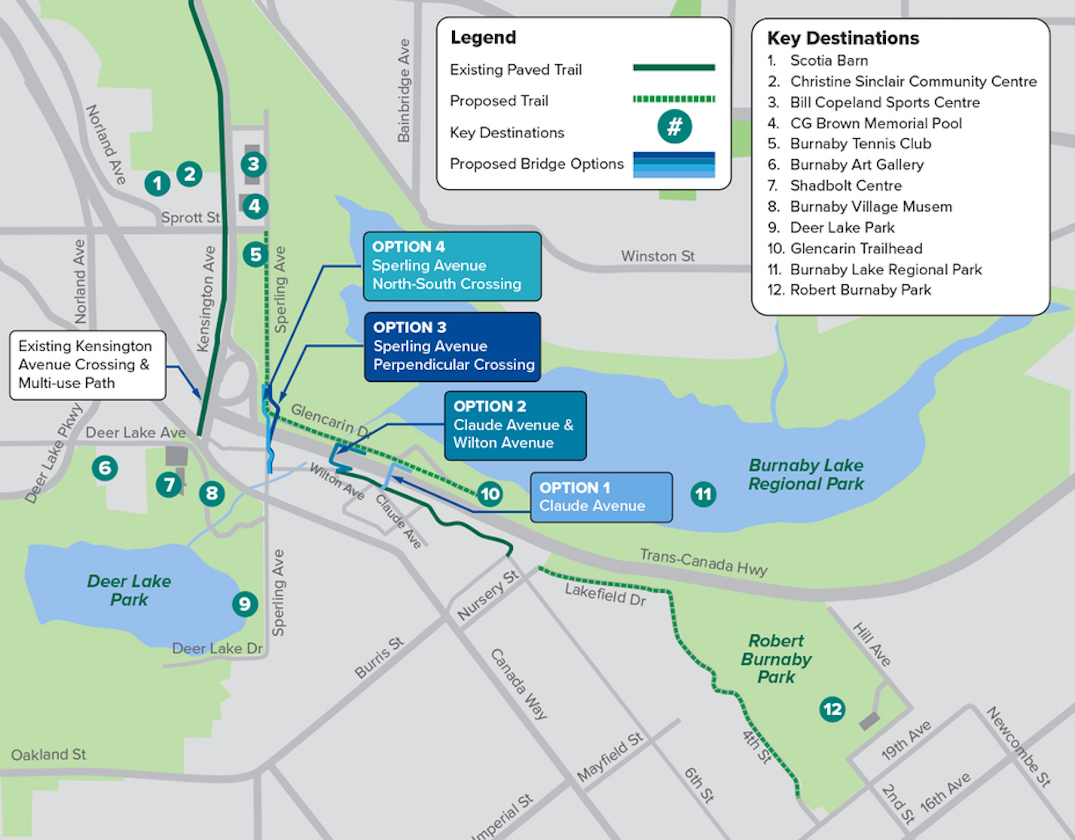
The municipal government has established a shortlist of four overpass location options that connect to various existing and extended trail pathways on either side of Highway 1. All options call for a landmark architectural structure suspended over freeway traffic, and are located in close proximity to each other within a 500-metre zone east of the Kensington Avenue interchange.

Map showing the four location options for the Highway 1 pedestrian and cyclist overpass between Burnaby Lake and Deer Lake. Click on the map for an enlarged version. (City of Burnaby)
While each location option carries varying functionality advantages and disadvantages for pedestrians and cyclists, they also have different construction costs. Aside from location, another key between the options is the length of the required ramping structures at either end of the overpass.
Here is a breakdown of the four location options:
Option 1: Claude Avenue
This location uses the existing high terrain on both sides of Highway 1 to reduce the need for a long ramp structure to access the bridge, effectively improving the user experience and reducing costs. The southern end of the bridge will be located within existing park space near the intersection of Claude Avenue and McCarthy Court, while the northern end of the bridge will be located at the trailhead at Glencarin Drive.
With the shortest ramps at the ends of the overpass, this appears to be the lowest cost option.

Option 1: Artistic rendering of the pedestrian and cyclist overpass design across Highway 1 between Burnaby Lake and Deer Lake. (City of Burnaby)
Option 2: Claude Avenue and Wilton Avenue
The overpass at this site will have its southern end at the bottom of a hill near the intersection of Claude Avenue and Wilton Avenue, and the northern end will lead to Glencarin Drive. Additional ramp structures are needed due to the area’s topography.

Option 2: Artistic rendering of the pedestrian and cyclist overpass design across Highway 1 between Burnaby Lake and Deer Lake. (City of Burnaby)
Option 3: Sperling Avenue (perpendicular crossing)
This option provides a perpendicular overpass of Highway 1 that roughly aligns with Sperling Avenue, with the southern end near the bottom of a hill at Sperling Avenue, close to a fire hall. The northern end will connect with Sperling Avenue.
Extensive ramp structures will be needed on both ends of the overpass due to challenging topography and the close proximity to the freeway’s on- and off-ramps.

Option 3: Artistic rendering of the pedestrian and cyclist overpass design across Highway 1 between Burnaby Lake and Deer Lake. (City of Burnaby)
Option 4: Sperling Avenue (oblique crossing)
An oblique overpass across Highway 1 roughly aligns with Sperling Avenue, with the southern end at the bottom of a hill at Sperling Avenue near the fire hall, and the northern end connecting with Spering Avenue.
Of all four options, this location requires the longest overpass length, and likely the highest cost. Similar to the perpendicular crossing option, extensive ramp structures will be needed on both ends of the overpass due to challenging topography and the close proximity to the freeway’s on- and off-ramps.

Option 4: Artistic rendering of the pedestrian and cyclist overpass design across Highway 1 between Burnaby Lake and Deer Lake. (City of Burnaby)
The municipal government has set aside $20 million for this overpass project from the $725 million portion of the 2022-2026 capital plan that is funded by community amenity contributions (CACs) from developers. The city has a policy of directing 80% of undesignated CACs towards community amenities, and 20% to the city-wide housing fund for affordable housing.
An online survey for the overpass location will remain open until May 1, 2022.
In June 2022, based on the public input received, city staff will present a location option recommendation to city council for consideration. If approved, detailed design for the bridge will begin in July 2022.

