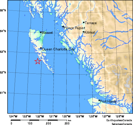
The 3.8-magnitude earthquake that rattled many in Victoria and Metro Vancouver last week is an important reminder that southwestern BC is one of Canada’s most seismically active regions and has a long history with earthquakes.

USGS/X
Experts suggest BC experiences about 400 quakes each year, but only a few are felt, and structurally damaging earthquakes only occur about once a decade.
That doesn’t mean BC hasn’t had deadly earthquakes or damaging shakers, and we looked into the archives to round up many of the worst earthquakes in the region.
M7.3 Vancouver Island Earthquake of 1946

Damage to the Bank of Montreal in Port Alberni, BC. (Earthquakes Canada)
The 7.3 magnitude earthquake was Canada’s largest historic onshore earthquake in history and happened just after 10 am on June 23, 1946, near the community of Courtenay and Campbell River. The epicentre was in the Forbidden Plateau area on eastern Vancouver Island; however, people felt the shakes from as far as Portland, Oregon.

Earthquakes Canada

Earthquakes Canada
According to Earthquakes Canada, people in Vancouver and Victoria ran out onto the street in fear when the quake struck. The impact on Vancouver Island was significant, as landslides were reported throughout the region. The force of the shakes knocked down many of the homes’ chimneys, and some roofs of essential buildings like schools were also damaged.

The earthquakes caused soil failure on the Kelsey Bay Highway North of Campbell River, BC. (Earthquakes Canada)
Tragically, two people were killed. One died when their small boat capsized due to an earthquake-generated wave, and another person in Seattle, Washington, died from a heart attack.
Nisqually Earthquake in 2001
In 2001, an M6.8 earthquake strongly shook Seattle and the Puget Sound area, was
widely felt in Victoria and Vancouver, and caused $2 billion in damage. While the epicentre was in the US, a magnitude of 3.2MwR was felt in BC’s southern region and as far away as Kelowna. In Vancouver, there was some damage reported, and it served as a wake-up call on how infrastructure was impacted and communication methods.
“The telephone service provider, Telus, experienced a complete system overload as a result of heavy public use following the preliminary event. Similar problems were experienced by the cellular network providers. This telecommunications disruption resulted in approximately 2 hours of telephone service delays in the City Hall complex,” a report from the City of Vancouver said.
Haida Gwaii in 2012

Due to modern technology, this earthquake is the largest instrumentally recorded earthquake in our region and analysis determined that it was a thrust earthquake with a magnitude of 7.7. There were no reports of structural damage or injuries when it struck off Haida Gwaii on October 27, 2012. However, it did generate a 7-metre-high tsunami and a warning was issued through the West Coast and Alaska Tsunami Warning Center.
Haida Gwaii Earthquake of 1949
Canada’s second largest earthquake happened on August 22, 1949 off the coast of BC underwater along Haida Gwaii.
“The shaking was so severe on the Haida Gwaii that cows were knocked off their feet, and a geologist with the Geological Survey of Canada working on the north end of Graham Island could not stand up.” Earthquakes Canada said.
The damage extended as far as Terrace, on the mainland, where someone described the shake as feeling like they were standing on a ship. In Prince Rupert, windows were shattered as a result of the magnitude 8.1 shaker.
- You might also like:
- Experts don't feel BC is prepared for a major earthquake
- 43 things every Vancouverite needs in their emergency kit
- What's the collapse risk of the downtown Vancouver viaducts in an earthquake?
The Cascadia Megathrust Earthquake of 1700
Earthquakes Canada says this is not only one of the largest earthquakes in Canada’s history; the magnitude 9 quake on January 26, 1700, was also one of the biggest in the world, and the tsunami it caused left major damage not only in Canada but as far away as Japan.
“The undersea Cascadia thrust fault ruptured along a 1000 km length, from mid-Vancouver Island to northern California in a great earthquake, producing tremendous shaking and a huge tsunami that swept across the Pacific,” Earthquakes Canada explained.
According to the First Nations people, the wave also completely destroyed the winter village of Pachena Bay, killing all of its inhabitants, and collapsed the homes of the Cowichan people and led to significant landslides as well.
Feeling freaked out? The Great British Columbia ShakeOut, organized by the British Columbia Earthquake Alliance (BCEA), will be held this month to educate and help residents prepare. To learn more, head here.

