
Downtown Vancouver's West End will see enhanced retail areas, additional density


Update: The City of Vancouver has approved the plan to accommodate 10,000 more people in the West End over 30 years.
After eighteen months of public consultation, a draft of the much-anticipated downtown Vancouver West End Community Plan has been created.
The plan maps out the diverse and densely populated community’s 30-year outlook and calls for further housing and retail spaces as well as improved public spaces and facilities. The 112 city block study area accounts for one-third of the area of the downtown Vancouver peninsula and is home to 45,000 residents, 23,000 jobs and millions of annual tourists.
According to the City of Vancouver, “the plan focuses on the physical city, and the functionality of its infrastructure in everyday lives: housing that is often too expensive, heritage resources that are at risk, local businesses that are struggling, accessibility and connections that are difficult or missing, and aging public facilities.” It warns that “if these challenges remain unaddressed, they will undermine quality of life.”
Vancouver City Council will convene before the end of year on the issue and is expected to approve much of the draft version of the West End Community Plan.
Enhanced Retail Villages and Commercial Areas
The new plan envisions the further development of the West End’s retail villages including Robson Street, Davie Village and Denman Village. It aims to enhance the context and built form of the village areas to strengthen their unique identities while respecting its existing character.
This particularly includes strengthening the three-block long Robson Street Village as a regional entertainment and shopping district, which has seen numerous store closures and prolonged empty store fronts in recent years. The plan will also further cement the Davie Village’s unique LGBTQ identity and officially establish a new retail district along Alberni Street.
Residential development will be limited in all three West End retail villages “to ensure vibrancy at all times of the day.” This element of exclusion is critical for encouraging vibrancy in the villages given the need to prioritize commercial needs over residential desires such as reduced noise and street activity in the evenings.
Commercial streets with high pedestrian foot traffic volumes could also see widened and improved sidewalks. This has been identified as a major priority by the community as streets like Robson Street Village are relatively narrow despite its high foot traffic volumes.
Other commercial zones like Lower Robson and Lower Davie (both beginning west of Jervis Street) will continue to see greater housing density and mixed-use opportunities. On Lower Robson, mixed-use development could allow for “larger format commercial uses that are viable on hillsides and will help animate the street.”
Decorative lighting, landscaping, public art and spaces for gathering will also be considered for all commercial areas in the West End. A four-block stretch on Robson Street between Bute and Cardero Streets will be designated as the ‘Robson Street Cultural Hub’ and could include a new arts/cultural themed plaza for events, art showcases and festivals.
Alberni Retail District
A two-block stretch of Alberni Street between Burrard and Bute Streets will become its own retail district given the recent emergence of luxury retail and restaurants along the strip. Alberni Street is anchored by the Fairmont Hotel Vancouver on its south end and the Shangri-La Hotel Vancouver and under-construction 745 Thurlow Street office tower on its north end.
Enhancements will be made to the street experience to develop the retail area’s unique identity and to encourage vibrancy and activity. This is also the only commercial street in the West End without bus routes which opens the possibilities to close the street for festivals and community celebrations.
The installation of permanent overhead decorative lighting on Alberni Street is among the list of proposed public realm enhancements for fostering the high-end retail district.

Davie Village
In addition to recent colourful installations such as the rainbow crosswalk at the intersection of Davie and Bute Streets and the creation of the ‘Heart of Davie Village Plaza,’ Davie Village’s distinct identity as Vancouver’s gay village will be strengthened with the use of more colour, lighting and improved spaces for nightlife, celebrations, events, gatherings and community programming. Additional commercial uses along the strip will also be encouraged.
Looking west on Davie Street near the intersection on Bute Street with enhanced public real improvements including the installation of an overhead ‘rainbow arch’ over the existing rainbow crosswalk.

A conceptual illustration of a second rainbow crosswalk on Davie Street approximately one block east of the existing Bute Street rainbow crosswalk and arch. A new plaza-parklet is also depicted on the north side of the block.

New tower height limits for additional density
In the plan, building height limits are reaffirmed and in some cases raised (bearing it does not intrude into the City’s established view cones, except in accordance with the General Policy for Higher Buildings) to provide additional housing and employment opportunities. This will promote economic activity and help reduce the city’s affordable housing shortage.
Of particular interest is the allowance of 700-foot towers on one city block bounded by West Georgia, Burrard, Thurlow and Alberni Streets across the street from Royal Centre. Vancouver’s current tallest building, the Shangri-La Hotel at 659-feet, is located at the adjacent city block on Thurlow Street and will soon be complemented by the 616-foot Trump International Hotel & Tower Vancouver directly across the street on West Georgia.
Other areas like the Alberni Street strip from Burrard to Denman could see varying heights between 385 to 550-feet. The West End’s Burrard Corridor, which intersects with Alberni Street to the north and ends at Pacific Street, could allow new developments with heights of up to 550-feet until Pendrell Street.
Additional density will allow for new housing stock to be built for residents of all income levels and families of all sizes, with a specific focus on increasing affordable and rental housing stock.
There is a need for 3,200 social housing units in the West End, however, the plan will only deliver up to 1,600 units. As well, approximately 1,900 units of market rental housing could be added through additional density and infill development.

Development in Laneways
In addition to increased podium and mid-rise heights along the West End’s commercial streets, infill ground-oriented housing along the neighbourhood’s laneways could provide another way to increase housing stock.
This will also enhance the laneways as “more walkable public spaces, potentially with improved lighting, gardens, landscaping, and traffic calming, while still maintaining integral servicing, parking and utility functions. The infill housing will increase the diversity and availability of rental homes in the community.”


Improved Infrastructure and Public Facilities
The walkability of the West End neighbourhood has been highlighted as a major concern by residents. Walking is by far the most popular choice for getting around as 40 per cent of the neighbourhood’s residents walk to work. Given this important mode of transportation, improved sidewalks will be given priority and could elements such as additional public seating and more pedestrian crossings.
This is particularly vital for busy commercial areas like Robson Street, where narrow sidewalks along the retail village have been problematic for the strip’s large crowds. The plan also recommends that the seawall along English Bay be improved with wider pathways with new, brighter lighting and opens the possibility of another passenger ferry (Aquabus) dock at the foot of Bidwell Street.
Click on image for enlarged version.
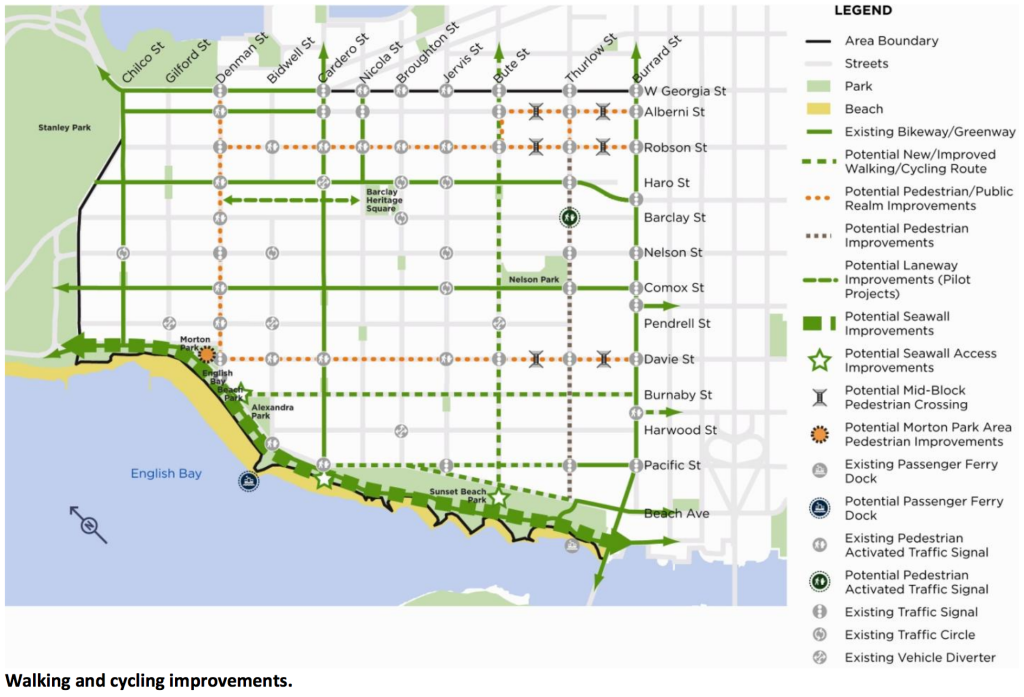
Additional and improved cycling routes and infrastructure, in addition to the introduction of public bike share in the downtown Vancouver peninsula, could be implemented. The City of Vancouver will also work with TransLink to relocate the bus layover area at the intersection of Davie and Denman Streets and “replace it as a timing point to maintain a more continuous service for buses through the West End.”
Click on image for enlarged version.

West End residents identified the need for additional green space and public facilities. The City will explore the possibilities of improving existing parks, building additional mini-parks, and the upgrade or renewal of the existing Joe Fortes Public Library, West End Community Centre and the Vancouver Aquatic Centre. These facilities are aging and are strained from high use.
Interesting notes about the West End
According to the draft plan:
- The West End’s population increased at a lower rate (19%) over the last 30 years compared to city average (42.8%).
- It was once the highest density neighbourhood in Vancouver (1970s to 1990s), however, it has not experienced significant population growth since the early-1970s.
- The average household size in the West End (1.5 persons) is lower than the city average (2.2 persons).
- The West End is the “landing pad” of newcomers to the city. It received 14 per cent of Vancouver’s new residents from 2001 to 2006 even though it is only home to 7.4 per cent of the city’s population.
- The West End is a highly mobile community with 66.4 per cent reporting to have moved since the last census compared to the city average of 50.2 per cent.
- The West End is a generally modest income community. Median household income ($38,581) is lower than in the city overall ($47,299). The percentage of the population in low income households (32.8%) is higher than in the city overall (26.6%).
- Many West End residents are able to work close to where they live, reducing the need to own a car. More than half (52%) of employed residents work in the downtown peninsula, and nearly two thirds work in Vancouver’s central area. This helps account for the West End having the highest walk to work mode share in the city.
- The West End currently has around one-third of Vancouver’s purpose-built rental housing and the second highest proportion of renters in the city (81% of households rent).
- 90 per cent of the West End’s rental units were built before 1975.
- Over 2,800 West End households spend more than 50 per cent of their income on rent. Of these households, 55 per cent are single, 27 per cent are families and 18 per cent are seniors.
- The 2006 census identified 1,300 West End families with children living in studio and one bedroom apartments. With 1,745 children aged 0-15 in the West End, anticipated growth will increase demands for childcare, education and family services.
- In 2011, 26 per cent of West End families had children at home, compared to 53 per cent citywide.
- The 20-39 age group is consistently the largest in the West End.
- The aging of the 40-64 age group will mean a growing seniors population in years to come.
- 60 per cent of seniors in the West End living alone, compared to 29 per cent citywide.
- The West End neighbourhood has Vancouver’s second-highest number of low-income residents, the third-largest number of recent immigrants, and third largest number of seniors.
- The West End is home to Western Canada’s largest LGBTQ population.
Images: City of Vancouver