
Three Category 4 hurricanes form over Pacific Ocean for first time in recorded history


It can not have been a good weekend to be a sailor, but it was a great weekend to be a meteorologist.
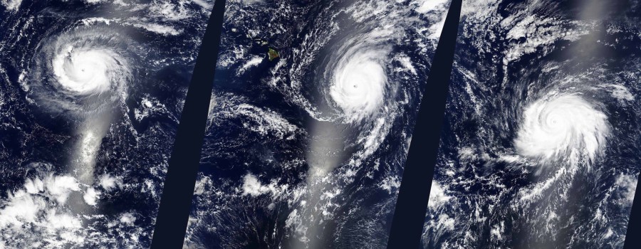
Three separate Category 4 hurricanes were active at the same time in the Eastern and Central Pacific Ocean between Saturday and Sunday, marking the first ever recorded instance of such an event, according to The US Weather Channel.
Hurricane Kilo, Hurricane Ignacio, and Hurricane Jimena all reached Category 4 status at various points over the weekend, the same day a wind storm ravaged much of Metro Vancouver, pulling up trees, taking down power lines, and leaving hundreds of thousands of people without electricity.
[am2_see_also]
Our satellite sees a tropical trio of Category 4 Pacific Ocean hurricanes: http://t.co/5dLV10dbor #EarthRightNow pic.twitter.com/aEgSggVNiy
— NASA (@NASA) August 30, 2015
While it seems unlikely any of the hurricanes will reach the coast, this is still meteorological history.
According to Simon Donner, Associate Professor of Climatology at UBC, the event isn’t all that surprising if you look at the current climate. He says that tropical cyclones require a few ingredients: high water temperatures, and a calm upper atmosphere.
“Normally when you have an El Niño event, the Atlantic doesn’t experience many hurricanes at all, because El Niño shifts the air flow in the upper atmosphere, such that the storms in the Atlantic tend to get sheered off,” Donner told Vancity Buzz.
“In the Pacific, the opposite happens. You have some sort of calm in the upper atmosphere, combined with extremely warm water temperatures, you get really strong storms. I’m not surprised to see this record of three Category 4 storms, when the water is as warm as it’s ever been, at least in recorded history. So it’s not that shocking.”
With reports suggesting that this year’s El Niño weather system will lead to another warm and dry winter for Canada, it can be easy to think things will only get worse. Donner says while warmer water temperatures can spell future problems, it isn’t the problem you might expect.
“Will it happen more often in the future? I don’t think we should have the expectation that it will happen every year,” says Donner. “[However], the science does clearly show that if hurricanes do develop and the oceans are warmer, they will get stronger. It doesn’t mean that we’ll have more hurricanes in the future, but it does mean that the ones that do develop will be stronger.”
[am2_see_also]
Hurricane Fred recently hit Cape Verde, marking one of the few times a hurricane has made it that far east in the Atlantic Ocean. Donner says that while the event is unusual, and likely related to El Niño and the rising water temperatures, it’s hard to say if they’re new, as it’s only due to recent technologies we’re able to track these events at all.
“In the past we only knew when they hit land. Now we can track a weak tropical cyclone that dies at sea, where as 80 years ago we might have had no idea, unless there was a ship there, that the storm even happened,” he says. “So it’s a little bit hard to say what was going on in the past in the middle of the Atlantic. The water is quite warm in the region around the Cape Verde island, so it isn’t surprising that a storm could develop enough strength. The weird thing is that it curved and went in that direction.”
While the future of weather patterns is still unclear, Donner says one thing is for sure: it’s heating up.
“On average over time the oceans are definitely getting warmer. That doesn’t mean summer they won’t be the same temperature, because there’s just some internal noise to how all this works, but they are definitely getting hotter,” he says.
“The oceans are unusually warm this year because of the El Niño event. They’re breaking records because of climate change.”
NASA Goddard MODIS Rapid Response/Jeff Schmaltz