


This article was written by Derek Delmar and originally posted to his blog, I AM CALGARY. Derek is a lifestyle blogger and Calgary Influencer, promoting people’s stories, family-friendly activities, and cool destinations in and around the city. He and his wife love all-things family and they love to travel. Derek can be followed on Instagram and Facebook.
As a newcomer to the City of Calgary, one has to quickly learn the lay-of-the-land if you want to have any confidence in navigating from point A to point B.
Even though the skill of self-navigating has fallen by the wayside with the modern day ease of access to GPS technology, it’s still worthwhile having a basic understanding of how your surroundings are laid out.
Any newbie to Calgary needs to understand how aspects of the city work, not least of all the “address” system.
I found this to be a very helpful orientation exercise when I landed here in August 2012. A reference to the map below might help understanding my descriptions to follow.
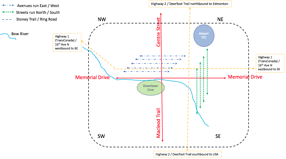 |
Calgary is segmented into four quadrants which are referenced in almost every single street address in the city, ie. NW, NE, SW and SE. Memorial Drive divides the city into North and South, while Centre Street (or its extension, Macleod Trail) divides the city into East and West.
The centre of the city is effectively at the intersection of Memorial Drive and Centre Street, just at the north end of the Centre Street Bridge. “Downtown Calgary” is located just to the south of Memorial Drive on the southern banks of the Bow River, straddling Centre Street.
In general, all avenues run in an east/west direction and all streets run in a north/south direction.
Stoney Trail is a ring road that nearly defines the edge of the city limits. The southwestern section of Stoney Trail is still under construction.
Two other key roads are 16th Avenue North (ie. 16th Avenue that runs east-west and is located north of Memorial Drive, not to be confused with 16th Avenue that is located 16 blocks south of Memorial Drive referred to at 16th Avenue South!) and also Deerfoot Trail.
16th Avenue North (or 16th Ave N) becomes the TransCanada Highway, or Highway 1, when outside of the city limits. If you continued west of Calgary on this highway you would eventually land in Vancouver, BC. Continuing east of Calgary will take you to the Atlantic provinces in the east!
Deerfoot Trail is a main arterial route running north-south across the eastern part of the city and is also referred to as Highway 2. Heading north on this highway will eventually bring you to Alberta’s Capital City, Edmonton, some 300 km away. Heading south on Highway 2 will eventually bring you to the USA border. You will want to have your passport ready if you end up there!
If you are arriving in Calgary by airline for the first time, you will no doubt be landing at Calgary’s International Airport, known fondly to locals as YYC, the city’s international airport code.
YYC is located in the northeast quadrant of the city. Be sure to check that any address you pass on to taxi drivers, friends, or your fellow travel companions is always specific to the quadrant you need to be in. Requesting a taxi service to take you to 7007 14th St could land you at any of four locations: a great sushi location in the NE, Nosehill Park in the NW, Rockyview Hospital in the SW or at a non-existent location in the SE!
Hopefully this provides you with a helpful framework to orientate yourself so you can start discovering the city for yourself.
Alternatively, you can check out iamcalgary.ca and I’d be thrilled to introduce you to some of my favourite spots across this ever-changing landscape.
