What Toronto Transit should look like in 15 years thanks to recent funding

Last week, the Government of Canada and Ontario announced they have committed almost $9 billion for Toronto transit projects.
According to the City of Toronto, the funding is being dedicated to building the Relief Line, SmartTrack, the Scarborough Subway Extension, waterfront transit, and the Eglinton East LRT.
“After years of delays and divisive debates, we are finally getting on with expanding our transit system, we are getting on with working together to build up our cities,” said Mayor John Tory in a statement at the time.
TTC Chair Josh Colle also commended the province and the feds for investing in our transit network.
So for anyone keeping track, there are some big changes to the region’s public transportation lines.
In case you were confused as to where the Relief Line goes, or what the Scarborough Subway Extension entails, this should clarify the future lines.

City of Toronto
Last year, the Government of Canada committed to providing more than $27 million through the Public Transit Infrastructure Fund to support the planning and preliminary design of a relief line in Toronto.
The relief line is a future rapid transit path that would relieve overcrowding on the Yonge Subway Line.
This week, the TTC Board approved $16 million for preliminary Relief Line South tunnel design, moving that project along.

reliefline.ca
The TTC’s Corporate Plan, released earlier this year, also outlined the potential new look for Toronto’s transit system.
The 2018 to 2022 outlook states that “in the next decade and beyond, customers will see significant growth in Toronto’s transit system… New rapid transit lines will reduce crowding and better serve high growth areas of our city; transit expansion will also improve access to employment and services for people with low incomes.”
The TTC will be making more accessible connections to the regional transit agencies in and around Toronto, including: GO Transit, UP Express, York Region Transit / VIVA, MiWay in Mississauga, Brampton Transit, and Durham Region Transit.
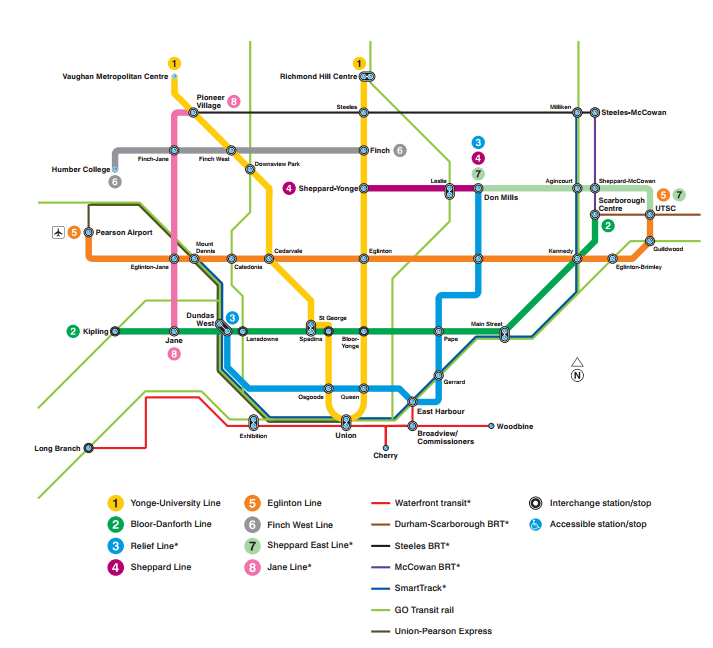
It also included its own version of Toronto’s future transit map.

TTC
“This map reflects the planning priorities of the City of Toronto, as presented to City Council on March 31st, 2016, and is a vision of what future rapid transit in Toronto could look like,” stated the TTC in its report. “The map does not reflect the level of funding commitment or analysis undertaken to date. This map includes both TTC and Metrolinx transit lines, which form a new, integrated transit network within the City of Toronto.”
The future of the TTC could see the addition of four new lines including the Eglinton Line, which could open in 2021, and Finch West line (2022), as well as the “Waterfront Transit”, which would extend services along the waterfront in five segments.
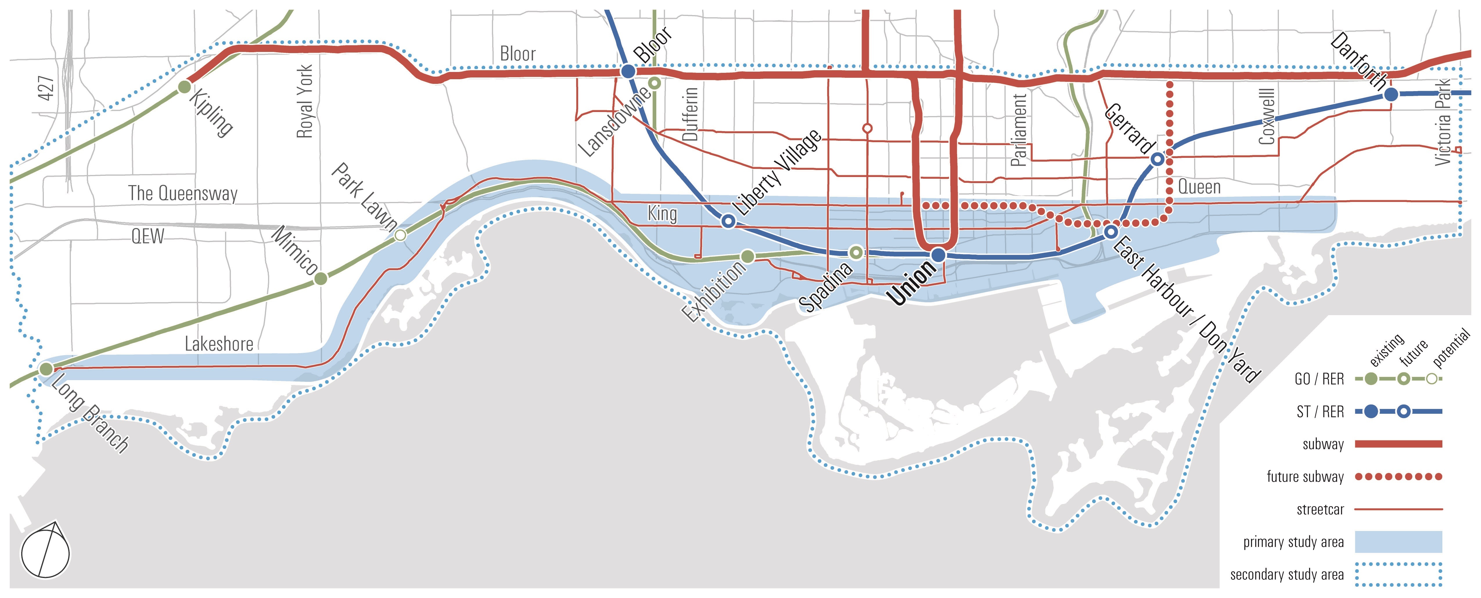
Waterfront Transit Study Area / City of Toronto
Not a bad transit outlook, especially if it all goes through as planned.
Here’s a closer look at the possible TTC future map.
See also

Follow Channels and Categories