
This map forecasts the number of trick-or-treaters you can expect this year


The scariest part of Halloween night? Running out of candy for hungry trick-or-treaters.
Thanks to Census Mapper you can avoid this tragedy altogether thanks to this handy Trick-or-Treat Onslaught Estimator that’s been put together using data collected in both the 2006 and 2011 census.
See also
- 54 things to do this Halloween in Vancouver
- 10 horror films to watch on Netflix this Halloween
- 8 haunted houses in Vancouver that will scare the crap out of you
- 10 great Halloween date ideas in Vancouver
This interactive Canada-wide map estimates the number of children of ‘prime trick-or-treat’ age per doorbell in various areas, aiming to give adults a heads up when it comes to the amount of candy they will need.
The darker the section the more children living in the area, and thus the more likely you are to get an onslaught of costume-clad kids at your door tonight. And Toronto has a ton of spooktacular dark sections including Riverdale:
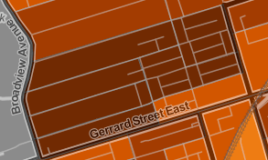
Censusmapper.ca
Between Yonge and Avenue just north of Lawrence:

Censusmapper.ca
Queen West just east of Trinity Bellwoods Park:
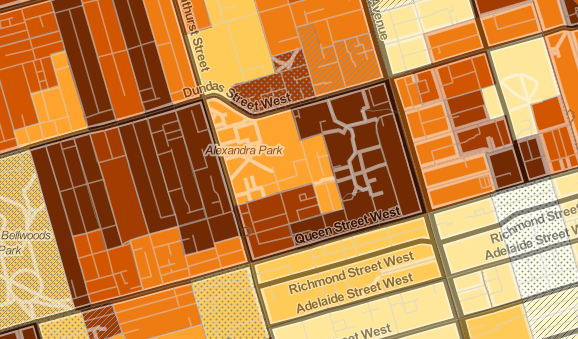
Censusmapper.ca
And all around Wychwood Park:
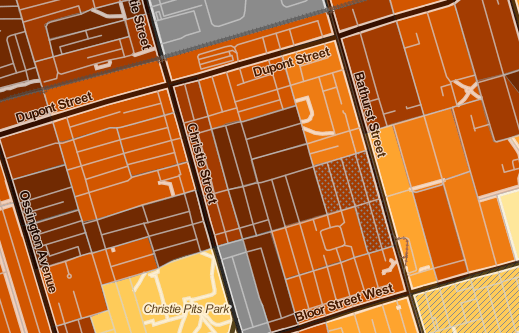
Censusmapper.ca
Check out the stats in your neighbourhood and see if you need to make a last minute trip to stock up on candy – can’t say we didn’t warn you!
If you’re looking for the best neighbourhoods to go trick-or-treating in or you’re interested in finding haunted houses in your area, there are maps for that too.

Follow Channels and Categories