City of Vancouver launches planning process to densify the Broadway Corridor

Earlier today, Vancouver City Council approved a $3-million, multi-year process to conduct the planning work needed to create the Broadway Corridor Plan (BCP) ahead of the completion of the underground Millennium Line Broadway Extension.
Similar to the Cambie Corridor Plan, the much-anticipated BCP will create a plan to densify the corridor, thereby increasing the usefulness of TransLink’s subway investment, while also curbing speculation. The BCP’s study area is framed by Vine Street to the west, Clark Drive to the east, 16th Avenue to the south, and 1st Avenue to the north.

Broadway Corridor Plan Study Area. (City of Vancouver)
The BCP intends to provide developers and property owners with guidance and clarity on what forms of development are permitted in this area. In the meantime, until the planning process is complete, no new rezoning applications in this area will be accepted, unless the proposals offer 100% social and supportive housing or facilities for community care or group residents.
The objectives of the BCP are to add housing – particularly rental and affordable housing – and increase the amount of job space on a macro regional and provincial economic context. Commercial shopping streets will be enhanced, public spaces will be upgraded, and transportation and connectivity revolving around transit and cycling will be improved.
Protecting rental units and limiting speculation
Much of the growth will centre around the six subway stations planned for the Corridor, with an emphasis on creating new rental stock and preserving existing rental stock. Rental districts are located within 800 metres of the stations.
According to a City staff report, 27% of the municipality’s total number of purpose-built rental units – totalling about 17,700 units – are located within the study area.
As part of the planning process, City Council also approved a policy called the Development Contribution Expectations In Areas Undergoing Community Planning (DCE), which is intended to reduce land value speculation over the interim.
The DCE will ensure “owners, realtors and developers are made aware of the City’s intention to preserve and grow affordable rental housing, job space and public benefits along the corridor. By articulating the City’s priorities and expectations at the outset of the planning process, sellers and buyers of land in the Broadway study area will be able to make better decisions with respect to land transactions.”
As well, the City will enforce contributions of $330 per sq. ft. for additional market strata residential in areas east of Main Street and $425 per sq. ft. west of Main Street beyond existing zoning.

Broadway Corridor Plan Study Area. Click on the image to enlarge. (City of Vancouver)
All of these measures well in advance of subway construction will address the shortfalls of the planning process for the Cambie Corridor Plan (CCP), which began the same year as the opening of the Canada Line. All components of the CCP were approved by City Council earlier this year.
“Land speculation can contribute to rising land costs, impact housing and job space affordability, and hurt the City’s ability to deliver affordable rental housing and provide community amenities to serve the needs of our growing population,” reads the report.
Relaxing height restrictions
The BCP will examine the possibility of changing the City’s view cone policy, particularly View Cone 3.1 from Queen Elizabeth Park, given that it severely limits the potential height and density of much of the study area.
“Broadway planning work will undertake urban design analysis and economic testing to explore whether select buildings along Broadway could enter into view 3.1 without eroding the overall view of the city within nature,” states the report.
“As part of this work staff will explore the potential of amending the General Policy for Higher Buildings to include sites along Broadway that provide additional housing and/or job capacity, strengthen the overall view, while contributing a heightened level of public amenity, green building advancements and architectural excellence.”

Queen Elizabeth Park View Cone 3.1. (City of Vancouver)
Additionally, City staff will review Cambie Street C-3A Guidelines and Central Broadway C-3A Urban Design Guidelines, which restrict heights along Broadway between Laurel Street and Yukon Street to preserve views to Vancouver City Hall from arbitrary public points on the north side of the False Creek seawall.
One other height restriction policy is mandated by the federal government to maintain a flight path to the helicopter pad at Vancouver General Hospital. The impact of the hospital heliport to building heights is most significant in the area between Oak Street and Laurel Street.
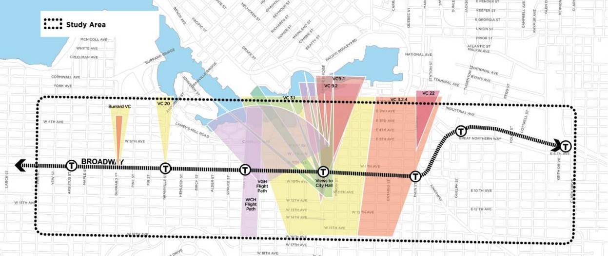
View cones and flight path height restrictions over the Broadway Corridor. Click on the image for an enlarged version. (City of Vancouver)
“There are already many existing buildings that protrude into the flight path area that are supposed to be clear. The City and VGH have agreed that proposals for new towers will be brought forward for review and discussion with VGH, Transport Canada and the helicopter operators,” continues the report.
“Through Broadway planning, additional review will be undertaken of the Vancouver General Hospital Flight Path in consultation with these stakeholders and Vancouver Coastal Health.”
The BCP will be completed over five phases, culminating with the plan’s finalization and approval by the end of 2020.

Broadway Corridor Plan Study Area. (City of Vancouver)
In 2016, the BCP’s study area had 71,500 residents and 69,000 jobs, making it the second largest employment centre in British Columbia after downtown Vancouver. In Metro Vancouver Regional District’s growth strategy for the region, downtown Vancouver and Central Broadway combined form Metro Vancouver’s only metropolitan core area.
The high residential and employment density has turned the Broadway Corridor into a regional destination, and this is reflected by the high transit ridership of over 100,000 boardings per day, including 55,000 boardings from the 99 B-Line alone.
Currently on the 99 B-Line, 47% of passengers end their journey somewhere along Central Broadway between Main Street and Arbutus. West of Arbutus Street, 6% disembark at Alma Street, 1% at Sasamat Street, and 44% at UBC.
Subway stations will be located at Great Northern Way Campus in the False Creek Flats, Main Street-Broadway, Cambie Street-Broadway, Cambie Street-Broadway, Oak Street-Broadway, Granville Street-Broadway, and Arbutus Street-Broadway.
Construction on the $2.83-billion, 5.6-km-long Broadway Extension is expected to begin in 2020 for an opening in 2025.
See also
- Vancouver seeks to curb land speculation ahead of Broadway Subway opening
- Broadway Subway cost estimated at $2.83 bilion, Surrey LRT now at $1.65 billion
- West Broadway Denny's to be redeveloped into rental housing and retail
- 32,000 new homes approved for Cambie Corridor in historic densification plan
- Cambie Corridor to house 50,000 more people from new density (MAPS, RENDERINGS)
- 200,000 total riders per day on Broadway Subway and Surrey LRT in 2025
- Vancouver reveals its desired design requirements for Broadway Subway
- Vancouver wants indigenous names for Broadway Subway stations
- These are the 6 stations of the Broadway Subway in Vancouver (VISUALS)

Follow Channels and Categories